Wirysaithe

Birthplace Of The Grannrormrlen
Wirythsaithe Wirthsythe Wirysaithe   (Previous title: The Riverlands)
The Riverlands is a region in west Pretheya which is hemmed in by the Silver Mountains to the east, the Blasted Mountains to the north, and the Barrier Range to the west. These incredible natural defences are what lead to it becoming the capital region of the Grannrormrlen, and defended it against invasion all the way up to the Landamaeri War. The region is commonly divided into sixteen separate sub-regions, which follow the geographical lines of former provinces set down during the Grannrormrlen. These are primarily used to refer to areas on a map, however, and cultural divides run along more organic lines.  
The region is most well known as the founding place of the Grannrormrlen. In the year that marks the start of the Reunion calendar, Forfir arrived in the north-east with a hundred Fyrstbairn, and there declared the founding of what would one day become the Grannrormrlen. In the following centuries, the Riverlands served as the empire's capital region, and would grow to become its industrial heartland as well; accruing near unimaginable wealth in the process. Though the fires of industry have long since been snuffed out, their markings can still be seen on the landscape a thousand years later, in the form
Open
"And on the first day of summer, the villagers of Wyrmheim saw a great form cresting the mountain in the horizon; and as they watched, that form was flanked by a hundred more. Towards them they began to march, with the light of the sun at their backs, and all in the village were awed beyond words; for they knew at once that their Lord had returned. And upon arriving at the village gates, the villagers prostrated themselves before the arriving Wyrms. Then, the one at their head - the greatest of their number - stepped forward and spoke thusly: "I am Forfir of the Ormr, he who was Forty-First among the Hundred, and I have come to be your shepherd."  
-Excerpt from Marcavian of Vinheim's The Grannrormrlen: A History
 
of vast areas of cleared land; industrial ruins; and the five Cardinal Waterways which the northern portion of the country is famous for.   In the present day, the Riverlands are home to a number of diverse cultures. In the years since the collapse of the Western Grannrormrlen, nomads from Ostokive have travelled through the mountains to settle in the western provinces, while small communities of Thousandforms have established themselves on the southern coast; brought to the region from distant Asutoa and farther-flung Intersedra in search of new trade opportunities. All the while, the Shahru faith - having long since dominated the rest of the Pretheyan continent - still struggles and fails to find any sort of a foothold in the region.
Alternative Name(s)
Is a part of Landamar along with Heralya
Type
Region
Included Locations
Riverlands
One of the many waterfalls from which the Riverlands earns its name
Controlling Polities: Split between almost a dozen petty kingdoms
Racial Majority: Tveirfotr
Minority Races: Thousandforms
Ethnicities: Many, but primarily split north; west; central; and south
Inhabitants Demonym: Landamaeri by themselves, Riverlanders by others
Notable Cities & Landmarks: Wyrmheim, The Granite Hold, Ennigaldi's Museum
Climate
Average Rainfall: Around 150 days a year
Snow in Winter: Often
Spring Temperatures: 5-14c
Summer Temperatures: 22-32c
Autumn Temperatures: 16-24c
Winter Temperatures: -5 to 8c
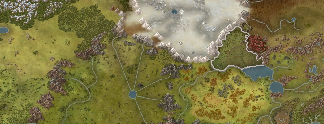
The Riverlands on a map

Geography

The region is commonly split into three thirds, which roughly comprise the fertile crescent in the west, the large Grannr-era agricultural clearings in the centre, and the industrial heartland in the north-east. These thirds are not geographically defined, and instead refer to political and cultural blocs that have formed throughout the region's history.
The eastern third is separated from the rest of the region and split into four by the Cardinal Waterways; four huge canals constructed during the Grannr to transport cargo to the city of Wyrmheim.  

Weather

Weather within the Riverlands is relatively tame. Rain is common, and there is a light drizzle for a few hours at least once a week outside of midsummer and commonly more often. Heavy downpours occur during the rainy season that can last for days at a time, and these can cause flooding in the immediate vicinities of some major and minor rivers. Snowfall is almost a given during the winter, and on rare occasions buildings may be snowed in and need to be cleared in order to allow people to leave. This is more common in some areas than others; with places near the Silver Mountains often experiencing particularly severe snowfall, and sometimes even avalanches.
A typical patch of pastureland in the Riverlands
 

Temperature

Temperatures throughout the Riverlands are similarly mild. Summers are warm, and they commonly reach around 28c; with particularly hot years getting as high as 30-32c at times, but rarely going far beyond this. Temperatures in spring are closer to 20-24c, and 16-20 is common in autumn. The region does become quite cold in winter; commonly dropping below zero degrees at night, and sometimes remaining that way for up to a week without thawing. It does not become bitterly cold, however, and temperatures below -6 are uncommon.  

North-East Third

The northern third of the Riverlands comprises the provinces of Fortefio, Sehuni, Greater Wyrmheim, Utrehu, and Ninoto. This area comprises a diverse spread of biomes; ranging from dense woodland in the centre-east on the border with the Blasted Mountains, to grassy plains further west. The level of the ground is somewhat uneven; with inclines of between 5 and 15 degrees common in many places, and hills a frequent sight. The majority of the land in this region has been deforested in the past in order to make space for industrial land, and so forests are found only in a few small zones where they were kept for logging. Elsewhere, trees are limited to small copses usually no larger than a square kilometre in size.   Almost all of the cleared land has been converted into either agricultural or pasture-land, save for that around cities. Near population centres, miles upon miles of land were once covered in factories, smelteries, workshops and other artisanal buildings that took in enormous quantities of materials from elsewhere in the Grannrormrlen and transformed them into finished products. In the years following the Grannr's collapse, many of these were abandoned and left to decline. This situation accelerated drastically during the Landamaeri War, and in the present day, most major settlements in the region consist of a populated core, surrounded by two-to-three times the inhabited portion of the settlement's size in ruins.  

Ninoto & Utrehu

The entirety of the province of Ninoto, as well as the northern half of the province of Utrehu, is comprised of grassy plains almost devoid of any tree cover. These areas are located at a noticeably higher elevation than the rest of the Riverlands, and so suffer from significantly colder average temperatures than elsewhere in the region. This, combined with seeming low quality soil, renders the region unsuitable for most crop growth; and so the majority of civilisation there has traditionally been either pastoral or nomadic.  

The Cardinal Waterways

The other defining characteristic of the north-east third of the Riverlands are the five great canals stretching from north, to east, to south; known as the Cardinal Waterways. Constructed during the era of the Grannrormrlen, these titanic waterways stretch to the edges of the region; intended to facilitate the transport of goods and personnel by canalboat and barge. In the present day, they still serve as the primary arteries of trade in the north-east, and they have allowed the region to remain wealthy and prosperous even despite the catastrophic downfall of the Wyrm states.   The five waterways serve as significant cultural and geopolitical boundaries; with the majority of the successor states to the Western Grannrormrlen having used them as convenient lines to holster up their defences at. Culture has also developed around them due to the fact that they inhibit land travel, and can only be crossed at certain bridges; which are viciously contested by the various polities in the region and used to restrict access as they please. The canals all lead to Centre Lake, which serves as the dividing line between the northern and central thirds of the country.  

Central Region

The middle third of the Riverlands is comprised of the provinces of Tosiforo, Eihousen, Tofhutir, Sononsi, Fortofret, Sehuni, and Ofihuet. In terms of space encompassed, it is by far the largest of the three 'thirds'; and realistically covers just under half of the surface area of the Riverlands.   The central region is the agricultural heartland of the Riverlands. Consisting of mostly flat land, interspersed by rolling hills with inclines gentle enough to allow them to be farmed, it was designated as the main agricultural centre of the region during the Grannrormrlen. As such, the vast swathes of forest that used to cover it were all cut down to make space for pasture and crop land, and only one large forest was left in each province. This has remained true up to the present day, and so the area is known for having very little other than farmland as far as the eye can see.  

Ofihueit and Sehuni

The two western provinces of Ofihueit and Sehuni are a part of the fertile crescent; a region known for having the most bountiful crop yields of anywhere in the Riverlands. They are separated from Tosiforo by one of the main rivers in the region, and so despite being included in the central region are culturally and politically diverse from their neighbours. Ofihueit, in particular, is home to a migrant population from Ostokive who differ the most from the other ethnicities in the Riverlands.

Powered by World Anvil