Kena
"Wö Kena at göna, ala meru jinta hortat."Kena is the homeland of the Kenaty people. It is a diverse land of plains, forest, mountains and deserts, and stretches all the way from the frozen polar region in the far South well into the Northern Hemisphere at its most northerly point. Its people pioneer in the arts and sciences, and its traders are well known throughout the old world.
Geography
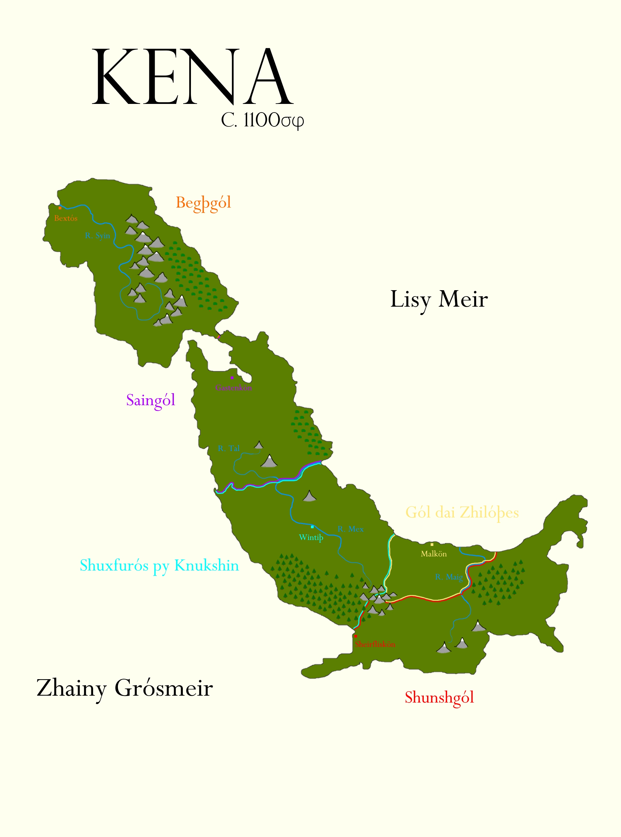
Kena is split into two major regions; Begþgól in the North and the rest of Kena in the south, which are joined by a thin land bridge. The geography of Kena is immensely varied due to its position covering a huge range of latitudes.

 A Lytsiþ tree in Begþgól
Although Begþgól straddles the equator, it remains fairly cool compared to other areas of the same latitude, as its proximity to the sea and elevated plateaus prevent extremes of temperature and bring plenty of rain. This makes the area extremely fertile and the western half of the region is the most densely populated region on Kena, particularly around the Syin Estuary. There is a large farming population west of the River Syin, and around the ports on the northern shore, where the area's proximity to northern Lisgól has made many ports important centres of trade.
Today, the region is under the control of the Kingdom of Begþgól.
A Lytsiþ tree in Begþgól
Although Begþgól straddles the equator, it remains fairly cool compared to other areas of the same latitude, as its proximity to the sea and elevated plateaus prevent extremes of temperature and bring plenty of rain. This makes the area extremely fertile and the western half of the region is the most densely populated region on Kena, particularly around the Syin Estuary. There is a large farming population west of the River Syin, and around the ports on the northern shore, where the area's proximity to northern Lisgól has made many ports important centres of trade.
Today, the region is under the control of the Kingdom of Begþgól.
 A Saingóly Trade Caravan
Today, the region is under the control of The Kingdom of Saingól.
A Saingóly Trade Caravan
Today, the region is under the control of The Kingdom of Saingól.
 Grósy Knukshinós
The West of the region is currently under the control of the Shuxfurós py Knukshin, whereas the East remains under the control of the Gól dai Zhilóþes.
Grósy Knukshinós
The West of the region is currently under the control of the Shuxfurós py Knukshin, whereas the East remains under the control of the Gól dai Zhilóþes.
 Cuncgól
Outline
Kena's highest point is the summit of Mount Sekt, a long dormant volcano located in southern Saingól which stands at 5012m above the surrounding plain. Its longest river is the River Mex, which flows from its source in the Cwunty Rulós mountains out to the sea at the modern border between Saingól and the Cuxfurós py Knukcin.Begþgól
The northernmost region of Kena is called Begþgól, literally "mountain land" in Kenaty (Language). The region is dominated by the Winy Begþö mountain range at its centre, but is also populated by the great Red Forest on its eastern shoreline, so called because of the bright red autumn blaze of the Lytsiþ Trees. The River Syin runs north from its source in the mountains, and out to the sea at the Bextós Estuary.Saingól
Across the land bridge from Begþgól lies Saingól, named "The Land of the Steppes" in Kenaty (Language), the region is defined by a large area of open grassland which stretches from Gastenkön in the North, south to the River Tal, and the foothills surrounding Mount Sekt. There is a large forest north of the Estuary of the River Mex, known in Kena as Lisy Knukö. Saingól lacks the fertility of its northerly neighbour. Whilst agriculture does occur along the River Tal and in the more fertile volcanic soil of The Gap of Kaidon, the majority of the Saingóly People live as nomadic herders (Ruleri) and as merchants travelling on caravans between the more densely populated North and South.Knukcinós
Central Kena is dominated by huge coniferous forests and wide open grasslands. The region called Knukcin, or "The Land of Many Trees" in Kenaty (Language), is as the name suggests, a densely forested region. It stretches from The Gap of Kaidon in the north down to the Swunty Rulós in the South, and to the River Maig in the East. The South of the region is covered in dense forest, known as Grósy Knukcinós. The largest city Wintiþ lies on the River Mex, along with most of the major population centres. The Mex river basin is intensely farmed, however the forests remain relatively untouched by civilisation and are home to foul and dangerous beasts.Cuncgól
The southernmost region on Kena is known simply as "Snowland" in Kenaty (Language), and is a mysterious, frozen land which stretches far into the Antarctic circle. There is a large boreal forest known as Knukcinós dai Maiges, and a frozen mountain range known as Shwuty Begþö, though few other than the harsh native Cuncux (Ethnicity) dare to venture towards them. The Cuncux (Ethnicity) exist mostly in small tribes of hunter gatherers and fishermen. There is a loose tribal confederacy who call themselves Cuncgól, and make their capital at Ceirfliskön, though they exercise very little actual control over the population. The tribes are frequently infighting, but rarely they do band together into large enough groups to conduct raids on South Kenaty (Ethnicity) settlements.Maps
-

Kena, Physical and Political
The continent of Kena is currently divided into 5 different factions. This map shows their borders and the main geographical features that define them.
Alternative Name(s)
Kenagól
Type
Continent
Location under
Included Locations
Included Organizations
Related Tradition (Primary)
Remove these ads. Join the Worldbuilders Guild


That's a lot of links. I feel tempted to click all... How am I supposed to pronounce "Begþgól"?
Thanks for reading :) the þ is an icelandic letter thorn and is pronounced like an english "th" or /ð/ and the ó is pronounced like the IPA symbol /ɒ/. Begþgól - /bɛgðgɒl/
In my languange(portuguese), ó has the same sound :D