Vithang Duicacht
The lands and settlements under the direct control and guardianship of Clan Vithang.
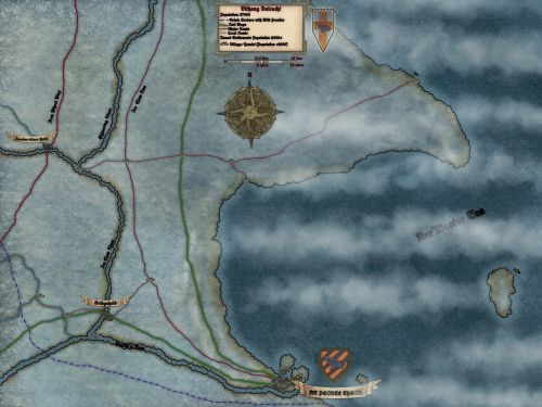
The Durin Province is famous across Suranth, and all the lands of the Northern Valerick, for innovation and invention. They are seen as a technological and industrial birthplace, a heartland, a boiling pot for new ideas and new technology. No where is this more true than the heart, the economic, political and productive center of the province, the lands entrusted to Clan Vithang, their personal Duicacht. The region contains but a few natural regions of note, but is good flat, forgiving land, so far as a tundra can be. Which makes it excellent for construction, and this is also true of transportation, especially by rail. This is likely a major contributing reason why An Pointe Thoir is well known as the birthplace of locomotion, and why such an invention could find the successful momentum and testing needed to prove the concept.
The Durin Province is famous across Suranth, and all the lands of the Northern Valerick, for innovation and invention. They are seen as a technological and industrial birthplace, a heartland, a boiling pot for new ideas and new technology. No where is this more true than the heart, the economic, political and productive center of the province, the lands entrusted to Clan Vithang, their personal Duicacht. The region contains but a few natural regions of note, but is good flat, forgiving land, so far as a tundra can be. Which makes it excellent for construction, and this is also true of transportation, especially by rail. This is likely a major contributing reason why An Pointe Thoir is well known as the birthplace of locomotion, and why such an invention could find the successful momentum and testing needed to prove the concept.
Geography
Below are very brief descriptors and hooks to give you an idea of geographic regions, as well as the larger towns. The towns will also have rough population listed in brackets, and a limited description of the place, along with two or three interesting rumors, hooks or facts. Villages will be but pins on the attached map, with a brief description and a population listed not much else.
GEOGRAPHIC PLACES OF NOTE:
Shivering River: This river gets its name from the Shivering Wood far north of it, which is where it originates. It is a fitting name by odd consequence for it is generally thought to be be the coldest river in the region, some well traveled folks have even stated their opinion it likely is the coldest river in all of Suranth. Yet oddly despite this, it does not freeze solid in the winter, indeed, it flows free and smoothly all year around. However some folk whom work or travel her waters regularly claim to have seen odd....beings below the surface in many areas, human like shapes but of water?
Ice Claw River: This river's name comes from a bygone age, it is old, ancient in name, and one of the only places who's name from before the Sundering is still with us, though why and where the name came from is lost to history. It is a rather swift moving river that flows out from the mountain lands to the west, moving to join Durin's Run on the way to the ocean. The regions of the river out to the west are a well known habitat for all manner of unpleasant beast. This includes, if the voices of a select few from Iarainn-alleos Fjord were to be believed, the hunting grounds and home range of a Glacial Wyvern.
Fin-Skinner Shallows: This coastal region is one of a few purposely avoided by most nautical traffic (and many would argue all nautical traffic with any good sense), because in the shallow waters along this peninsula, there lurks danger amidst its wildly vibrant, particularly for arctic waters, kelp 'forest' and reefs. These regions exist because a rather large stretch of water, about fifteen kilometers out to sea and along fifty or so kilometers of coastline, is home to large volcanic vents which warm the waters greatly. Many the interesting sight can be seen in this strange stretch of water, but the temptation is dangerous, for the region's name does not come from an odd fish or shark or fishing practice. It is the local slang for the merfolk that live there, filthy Scaled Ones whom take great delight in skinning their victims alive. A select few.....esoteric scholars, have suggested they do not do this merely for pleasure or entertainment, but to feed their reef and kelp forest on suffering. At least one scholar, who's name has faded into obscurity, had also suggested ideas far more sinister.....
TOWNS/CITIES:
An Pointe Thoir (18497): https://www.worldanvil.com/w/tariek-rough-collection-twaren-stormborn/a/an-pointe-thoir-settlement?preview=true?
Bridgehold (5391): This large town is oft referred to as the 'Outer Bailey of An' in reference to its location and position in relation to An Pointe Thoir, and it is an apt comparison. They hold the river crossing for the Ice Claw River and as there are no crossings for Durin's Run, this is the only real approach from the south without being easily noticed. Besides this, their centralized location within this busy area on the banks of two major rivers and where they meet, in control of the river crossing for the railway, and less than a day's march from the main road, indeed the road that runs to An Pointe Thoir, the reference to the town as such makes total sense. This town is a busy hub of military and transportation, and a garrison point for all three common sorts of military patrol forces (Road Wardens, Coast Guard, and Rail Wardens.). Recently the town has been plagued with a string of break-ins and murders. Nothing of note is taken, or so it would seem, and local police are stumped. There have been six victims so far.....
Iarainn-alleos Fjord (4381): This large town gets its name for the impressive metalworks creation by the local engineer, and metalworks, that is the bridge that gives the town its name. The town is actually well known for its inventive spirit in regards to all manner of weapons and military supplies. Though An Pointe Thoir is where many of these successful inventions are manufactured en masse when the time and success of the invention comes to that point. Most recently of course, is the Bédgathirr, or as its known by most whom encounter its use in manuscript or in person (and survive), the Flame-Spitter. The town is in a state of alert now though, for two scout patrols have disappeared in the last ten days, both on missions to scout to the west.
Maps
-
Vithang Duicacht
Type
Territory
Owner/Ruler
Ruling/Owning Rank
Owning Organization

Comments