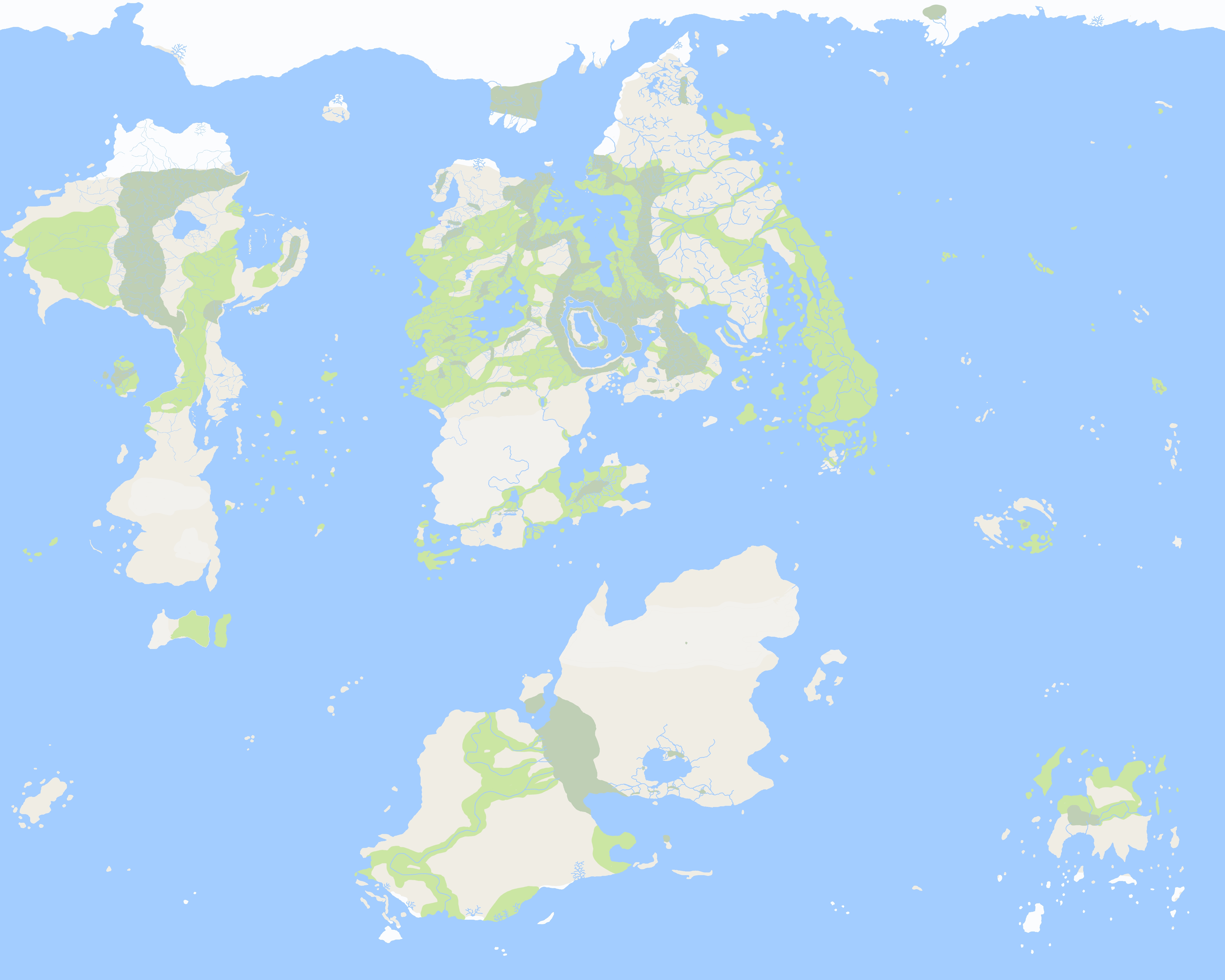
River Suederum (su:ˈeɪdɛərəm)
River map
Geography
The River Suederum is a river that flows through West Quentar, including Iscors. It is the chief river of Monapturary and it is about 490km in length.
 Suederum watershed
 Regions of the Suederum Valley
Toponymy and mythology
Suederum is derived from the name of a pre-Ghasscari tribe that lived in the area, known as the Suurtti or Suederi. The Ghasscari believed that the river was home to the three nymph daughters of the God Telonus known as the Latonaeds. The daughters were all the wife of the river spirit Suerotes who slumbered deep within the White mountains. In myth, the daughters are only three of four quadruplets born to Telonus and the ice goddess Nive. All four were promised to Suerotes, one for each of the four seasons. The remaining three daughters attempted to attend to their husband, but his anger led to frequent outbursts (floods). The Ghasscari made offerrings to the Latonaeds for safe passage on their husband's river and they were worshipped as protective spirits. In contrast, Suerotes was a capricious and gluttonous figure who was reviled. Nevertheless, Suerotes' name was adopted by the Murixi when they entered the Suederum valley during the decline of the Ghasscari empire. Suerotes was translated as Sowerdoter, which later diverged into Suederum in Anneliyan Ghasscari. In Malascari, the river became the Suiverder, in Oscavien the Cuideterre, and in Fermian the Sowwer Dochwra or just the Dochwra.Hydrology
The river rises at Santhur on Lake Garlan in the White Mountains and flows into the Sea of Pourtouge near Witchhaven via the Suederum delta. From the southeast it flows through Maronium, Licius, and Mareune. The Upper Suederum has three branches, the White Suederum, the Black Suederum, and the Green Suederum. The White Suederum is considered the principal branch, which issues from Lake Garlan and then flows north-west through the White Valley where it meets the Green Suederum. The joint stream passes through several gorges and falls towards Lake Doulga, where it meets the Black Suederum. After Lake Doulga, the valley broadens out towards Maronium. From Maronium to Licius, the Suederum flows through a wide and shallow valley, bordered on the east and west by the Nanos Hills and Toren Hills. Farther on from Licius, the current becomes more sluggish and the banks are flat. In the Iscarod, the course is deflected to the west and enters into the swampy marshes. The channel bifurcates several times and the Suederum degenerates into a stagnant course of parallel streams. The river floods every three to four years. Abnormal precipitation in the upper basin saturates the soils, leading to winter floods. The floods disproportionately affect the southern floodplain due to differences in relief. Hence, most towns on the Suederum are found on the north banks of the river. Once or twice a century, the Suederum experiences catastrophic floods due to glacial outburst events in the White mountains. Surging glaciers cause an outburst flood that rushes down the course. Maronium was partially destroyed by such events in 776, 501, and 317 AT.Economy
The Suederum between Maronium and Iscors is a great traffic highway. It links the Ekattaneries of Maronium and Licius to the sea through the wharves of Iscors. Most of the traffic is carried on flat-bottomed barges hauled by horses along the river's natural levees. The harbour at Garecess links the Suederum to the River Hadre via the old Ghasscari road. The water of the Suederum is itself valuable to the fluvial communities. Watermills power forges, weaving houses, and lumberyards all the way from the upper valleys to the Iscarod, where the river spills into the marshy delta and loses much of its power. The Suederum valley is known as a land of bridges due to the vast number of crossings. Many of the oldest bridges are fortified castles, enabling their owners to collect a toll from travellers going by either land or water. Other bridges, such as at Mareune, formed the nucleus of trading settlements. Many bridges have inns and coachhouses built alongside them, giving travellers frequent opportunities to rest as they move through the Suederum valley. The economical value of the Suederum as a highway fluctuated over time, largely as a function of the navigability of the Iscarod. The major cities grew and declined in response to their access to the sea. Under the Corporate Dominion, the Suederum valley was a major breadbasket and a large irrigation network was built across the floodplain.Politics
The Suederum has frequently been used as political boundary by human polities, with the first recorded use being between two pre-Ghasscari tribal federations. Under the Empire of Ghassum, the Suederum formed the boundary between three provinces. During the decline of the Ghasscari empire, the Murixi tribal confederation entered the Suederum valley and established several settlements along the Suederum's course. The Corporate Dominion of Velaire used the Suederum to distinguish the homelands of the Demes de Munde and the territories of Autre Estay, forming the County of Cosiay in 620 AT. The 397 AT War showed an alternative political function of the Suederum- a highway. Mercenary forces used their control of the headwaters of the Suederum in the White Mountains to raid the Dominon's profitable estates in the valley. The Rebellion of 393 AT was able to drive the Dominion from the valley entirely by seizing the key river ports. After the decline of the Corporate Dominion, the Suederum resumed its barrier function, marking the northern frontier of the Empire of Quentar founded by Emperor Culk I. However, the Suederum was hostile to the Empire and many villages in the valley fought for their independence. Between 350 AT and 200 PT, several wars were fought for influence in the Suederum Valley between Osgau and the Empire, eventually settling the border on the Suederum and granting pariage to the cities of the valley. Between 380 AT and 250 AT, the Suederum delta was home to several piratical groups based in old Dominion towns like Iscors, Cars, and Semars. The Delta was historically a place of refuge for bandits, outlaws, and refugees fleeing violence, as its fluctuating streams and uneven surfaces made it challenging for armies to exert control over the people living there. During the Dominion's control of the delta, the influx of wealth enabled the monscelt flats to be partially drained, increasing control over the region. After the Dominion's collapse, pirates began operating out of the old Dominion bases and raided sea traffic on the Sea of Pourtouge. Pirates raided shipping in flat-bottomed oared boats and targeted isolated lighters attempting to enter Pourtouge or Sarx.Literature
The Suederum features prominently in Malascari literature and its course is the subject of romantic and patriotic legends. The Iscarod and the lower course is often the home of witches and other swamp-dwelling beasts. The middle course is often fixed in the political imagination as both a bridge and a highway, a place where adventurers can make their fortune. The gorges, falls, and swampy valleys of the upper valleys are sites of the legendary acts of the Thirteen Sacred Soldiers, the first Malascari, and the ancient Ghasscari. The river cuts a romantic white line through its green and fecund valley as it descends from the white-capped peaks of the White Mountains. Shielded by the moraine of the Southern Massif on its left bank, the Suederum is often held as the great mother of the Malascari, nursing them through their settlement of the valley. As Malascari culture diverged after the 397 AT War, the Malascari in the Hadre valley developed their own artistic and literary traditions.Ecosystem
White Mountain Meadows
The lakes of the White mountains, from which the Suederum rises, drain the swampy upland region. The clay plain of the meadows form innumerable swamps, lagoons, and side channels. The flow of streams are retarded by growth of tall grasses. These patches of vegetation are barriers to navigation on the lakes and river systems, but they form a rich ecosystem. The sluggish waters are host to large populations of parasites that carry waterborne diseases and the region is sparsely populated. Hundreds of species of birds are found in the meadows, hosting large populations of migrating birds during winter. During summer, the meadows form a haven for migrating animals coming down from the White Mountains. In autumn, late in the growing season, alpine shrubs and trees burst into flower for a few brief weeks, turning the quagmires shades of purple, yellow, and blue.Upper Gorges
The stretch of the Suederum between Lake Garlan and Lake Doulga is characterised by a deciduous chaparral biome, warm all year with lower precipitation than the more westerly valleys. The soils, unlike in the upper meadows, are unsaturated and life is concentrated around the Suederum streams. The upper soils dry out during summer and the hills are dominated by sclerophyllous mixed woodlands. A thick shade of deciduous tree cover provides a constant layer of leaf litter that acts as the main energy source for aquatic food webs. This organic matter is consumed by aquatic shredders, which include the White water shrimp, grassflies, and bee larvae. These organic communities are easily washed downstream to Lake Doulga, where they accumulate in a thick biotic layer on Doulga's surface. These insects provide food for many terrestrial organisms like birds and amphibians throughout the Suederum river system.Middle Course
The increasing width of the Suederum after Lake Doulga means tree cover provides less shade for the water flow, restricting shading to the margins. This allows light to reach the river bed and allows for abundant algal growth, especially during periods of slow stream during the summer months. Grazers and scalpers consume these algae and a few fish species, like the berch and freshwater tream, can thrive on these organisms during the autumn. As the river enters the valley towards Maronium, the accumulation of suspended sediment prevents light reaching the riverbed and algae populations fall. The lower valleys also receive more precipitation and their soil fauna provides a rich bed of nutrients. The woodlands display much more significant seasonality due to its more restricted growing season. The trees are deciduous, as on the banks of the upper river, and autumnal leaf-fall provides a rich source of nutrients during the winter season. Large mammals are found throughout these forests, although much of the pre-human vegetation has been lost due to deforestation, which has converted large swathes of land into cropland and pasturage.Delta
The delta system is a naturally marshy region supporting a rich ecology of numerous species of birds, eels, and plants. The delta has been partially drained by drainage channels and watermills, forming a landscape known as the monscelt. The marsh lies only a few metres above sea level and it is crossed by several tidal creeks. During winter, storm surges can raise the sea level above the monscelt and cover the land in a thick layer of mud. The local conditions are ideal for peat formation, which is often harvested by human inhabitants of the delta for fuel. The delta system relies on the constant influx of sediment from the Suederum as tidal processes frequently erode the delta front.Localized Phenomena
The Delta frequently experiences hivers in late spring- cold sea fogs caused by cool oceanic air meeting the warm marsh water. The fog is common to many shores of the Sea of Pourtouge, but it travels significantly further up the Suederum than other rivers.
Natural Resources
Medicine
The Malascari were renowned across West Quentar for their knowledge of medicine. Medicinal plants grew all across the Suederum valley, although the most potent analgesics were derived from the meadows of the White mountains. In contrast, the best antiseptics grew amongst the monscelt mudflats and were very challenging to harvest outside of springtides.Timeline
History of the Suederum Valley
Alternative Name(s)
Sowerdoter, Suiverder, Cuideterre, Sowwer Dochwra
Type
River
Location under

Really well thought out article. You even added a section for literature! Those maps also look great, like they could come straight out of an atlas.