Nelqora
Nelqora, considered as a geographical unit, is vague as for its locales. What information is available are only scraps of journals or tattered maps of the ancient island. Further political disagreements—stemming from desires to use the legendary locations of the island in national myths—renders any information drawn from these sources as suspect. There have been many forgeries and false academic works bent on various agendas. Still, this article attempts to describe the island as most agreed upon by most Nelqorana scholars, and will attempt to describe some of the locations believed to have been on the isle before its sundering.

The Geography
The Isand of Nelqora was situated at the extremest northern point of any known lands, being about 950 miles north of the Lama Promontory, the northernmost point of the continent of Tizüb. It was bounded to the southwest by the Thrija Ocean, to the southeast by the Koraxkha Sea, and to the north by the Arctic Sea. The Kjan-Kullarvo Sea was a body of water considered within the Island of Nelqora's territory proper, lying south of the mainland but north of the Tadpole Tail island chain. The Island of Nelqora comprised an area of about 77,220 square miles, and at the peak of the Empire of Nelqora's power had a population of about 20,000,000 souls. About 10,000,000 of these were the dark-haired southerners, and about 2,000,000 were the fair-haired northerners, about 8,000,000 were slaves from various realms of the colonial empire, which drew levies from realms as far apart as Greater Huraedon to Moinen.
The island was unevenly bifurcated by the Ic Biliiz, the High Middle Ridge, the highest mountain range on the island. So it was proper to delineate the island into three main sections: the northern wastelands and tundras, the southern forests and plains, and the far southern islands.
The principal rivers, none but the Nyslott carrying great volumes of water, were the Nikkitra, Oitzi, and Maki, emptying into the Thrija Ocean, and the Nyslott and Parosii, emptying into the Kjan-Kullarvo Sea. These rivers have probably been destroyed or changed as of now, the Sundering of Nelqora being near total in its destructiveness, but none can confirm this. The coast is fairly rocky and icy.

The four seasons of the year, common in most countries, are mostly unknown to Nelqora. Being so far north, the island was in perpetual winter, though there was no snow in the southern lands. The only vegetation that could survive there were those that were specially placed by the gods to grow there. The denizens of Nelqora divided the year between the dark and the bright seasons, referring to the times when the Sun would either stay out for all of the day or all of the night during summer or winter.
During the winter, glaciers would expand over the entirety of the northern island and expand greatly over the western and southern lands. Furthermore, in winter all open waters would freeze—although the Koraxkha Pass, composing of the Kjan-Kullarvo Sea and a narrow corridor passing through the Bethan Delahd Islands and continuing farther south, would remain ice-free year-round.
Now we will treat of each of the individual administrative states of Nelqora, and detail their terrain in turn.
State of Abo
How lovely is this place!
Abo was the breadbasket of the island, and housed the majority of the Nelqorana populations because of its peculiar virtues, rendering it warm amidst the cold land. In its heyday fields would yield a harvest four times a year, and it was so densely populated that there was always a village or greater settlement within an hour's walk. Broad, gentle plains continued for many miles, interrupted only by cool streams and various copses of oak, poplar, pine, and cedar. The weather was always temperate and easily predictable; and in winter it was only cool and never snowed, though the nights still grew long.

To the north was the mighty volcano Asklja and the Lake Asklja. The river Nyslott flowed downwards from here, and after winding its way through the central valley turned westwards and formed the farthest western borders of Abo. Then, the river turned southeastward and spilled into the cool waters of the Kjan-Kullarvo Sea, splitting into three branches, forming the Ajan-Kai Estuary, the most fertile lands of the fertile valley. Throughout its flow the Nyslott would bring the rich earths of the mountains down to the lower valleys.
The Vale of Abo was bounded to the north by the High Middle Gird, to the west by Nyslott and the Kasa-etel hills and forests, the south by the Kjan-Kullarvo Sea, and the east by the woods of Abattarick and highlands of Armiinolos.
A special note will be given to the volcano Makai. It was considered a little, dead thing, of little note in the great list of volcanoes that filled the island and dotted the underwaters of the Kjan-Kullarvo Sea. But its sudden eruption began the collapse of the Nelqorana Empire, giving rise to the Uman phrase "he's a Makai"—meaning that the person was a sudden interruption or revolution that defied expectations.
State of Abattarick
Vaka vanha Väinämöinen, Steady old Väinämöinen
While the State of Abo was the most bountiful of the regions of Nelqora, the State of Abattarick, the land of lakes and woods, was the most beautiful. Today, it is a wasteland of crystal and glass, most of its vegetation destroyed in the collapse of the Folvkin Palace. But the beauty of Abattarick has been captured in many Nelqorana poems and songs, so that even today we may relive its lost glories.

It was a flattish region, dotted with many rivers and lakes, which would flow downwards from the northern hills towards the rocky coast. The lakes were of such clear quality that the central woods that dominated the region was called 'The Woods of Crystal Lakes'. The coast was edged with rills, rias, cliffs, caves, and coves. Many small harbors could be found, there, and so Abattarick became a popular getaway spot for the wealthy. Summer homes were established alongside massive meaderies, and extravagant parties were held in halls with high rooves and many silver pillars.
The most famous of these meadery homes was Eestir's Meadery, located towards the northeastern coast, just north of the Yiisvii Inlet, built along the Puuna River. Its honey was gathered from the mouths of golden bees, and its mead brought back the energy of youth to any who drank it—and also potent virility.
A cold place even in summer, Abattarick was inhospitable during winter. The residents of this place were largely nomadic herders, driving thick wooled sheep or furred cattle; or they were hunters from Abo, wintering so that they could find and capture rare creatures of the snowfall. And besides Abo, Abattarick was the home to the most eyries on the island. So many of the Eagle-masters would be long-term residents. But storms were sudden and unpredictable and thrashed the woods with their violent gales. And it rained often, regardless of the time of year.
Abattarick was bounded to the north by the hilly Armiinolos region, to the west by the Vale of Abo, the south by the Kjan-Kullarvo Sea, to the east by the Mânoi-etel.
State of Armiinolos
Behold her, single in the field,
Yon solitary Highland Lass!
The northern highlands of the Southern Regions, Armiinolos was the home of wild nomads used to terrible material and geographic conditions. It was never greatly developed by the Nelqorana.
It was a hilly region, filled with many small streams but no major waterways, girded to the north by hills and mountains, and to the south by the thick forests of Abattarick and Wesiirin—therefore highly defensible. The mighty Cewan trees only grew, here. They were trees of incredible height, evergreen, and with boles so thick that it would take twenty men to wrap their arms around one. The Awenyuun tribe were famed for their fabulous palaces and room carved out of the trunks of these trees. There were also many volcanoes.
It was rainy, here, though it didn't rain as often as the coastlands. The weather was unpredictable, although some tribes claimed they could predict the rains by determining the brightness of the Hut Constellation's southern star.
The Mânoi-Etel
And he said, Draw not nigh hither: put off thy shoes from off thy feet, for the place whereon thou standest is holy ground.
By far the holiest land in Nelqora, the Mânoi-Etel was a dry region of many small lakes and streams, always windy, and always cold. Its center was dominated by a raised flat made of a matter that looked like salt but had the properties of phosphorous. Tall, iron poles leered over this plateau: constructions of the Nelqorana to help travelers. Some of them were repurposed by ascetics, who would sit on them, eating and drinking almost nothing. Towards the coast the land became more hospitable, and many saunas were built around the lakes, there. This was how Zakalab was founded. It was built on a volcanic pool.
Perhaps the Mânoi-Etel was holy because of its inhospitality. In its drought for life the Nelqorana placed onto it their desperation for sacred hardships and victories won over these hardships. Either way, it was a land without many exploitable properties, so few lived here. Those that did lived on the coasts, their livelihoods bound to the fisheries and trade with the peninsular citizens of Intiil and Dubdaa-zor.
The weather was difficult to predict along the coasts. The central flats had almost no rain and were continually windy. It was easy to predict the weather in the central flats.
The Mânoi-Etel was bounded to the west by the woods of Abattarick, to the north by the hills of Armiinolos, to the east by the woods of Wesiirin, and to the south by the Kjan-Kullarvo Sea, bordering also the peninsulas of Dubdaa-zor and Intiil.

States of Dubdaa-zor and Intiil
For industry's sake, work on.
The two special administrative regions constituted a similar geographic unit. They were peninsulas with rocky coasts, overall flat, but rich in mineral wealth, especially iron and copper. The local governments were under constant stress due to the storms that beat against their shores. There are few lakes and only small rivers.
The peninsulas were the most densely populated regions after Abo. Their closeness to the Cliffs of Salt, their impressive industry in various ores, and their closeness to the Bethan Delahd islands meant that much mercantile traffic passed through them. Consequently, many settled there. But while they are interesting because of their human industry, they have little impressiveness in ways of geography, with no distinguishable features.
State of Wesiirin
"The little wood opposite—how delightful to sit under its shade!"

Wesiirin could be separated into two sections: the northern and southern. The southern lands, the most important of the two, consisted of great forestries, gypsum mines, shallow coal works, and great salt mines along the Cliffs of Salt, though the soil was not good and quite sandy. It was always considered a rich land, ripe for exploration and industry. More people lived in the south by the comparatively warmer waters of the Kjan-Kullarvo Sea. The northern lands were richer in minerals but harder to live in, being farther from the great trade that came through the Koraxkha Pass. The minerals that are most common in Wesiirin are iron and copper, producing about 30% of the total iron and 80% of the total copper of Nelqora during its golden period from 1250 - 1490 Year of Nelqora. But Wesiirin was never fully exploited and was filled with virgin woods even by the time of Nelqora's sundering.
Wesiirin was an especially difficult place to live in because of its position between the cooler northern seas and the warmer inner sea of Kjan-Kullarvo. Great, unpredictable storms whipped the region and would cause terrible devastation among the peoples that lived there. Extreme efforts were made to build storm-breaks and storm walls in this area, though none did their job effectively. But some good came out of this. It was only in Wesiirin that the Nelqorana could make their famous Ice-fire bombs—a unique alchemical creation made from the mixture of lightning striking the salt cliffs of the south.
Some extra space should be given to the great salt cliffs of the region. The Cliffs of Salt were quite literally cliffs made of salt. It was not a euphemism to a region along the cliffs that was rich in the mineral. Indeed, the Nelqorana could scrape from the cliffs as needed—although there was danger in this initial venture, and the salt was later processed for greater flavor. They were of incredible value to the Nelqorana, and were heavily exploited. As the cliffs were increasingly mined, and the ground became more unstable and prone to collapse, more specialized tools were required to dig into the earth and draw from it the needed salt. And with the Sundering of Nelqora, we do not see how these cliffs could be exploited anymore. Still, the Nelqorana certainly got their money's worth by that time.
State of Gunpul and Bethan Delahd
. . . the Haven of the Swans, lit with many lamps. For that was their city, and the haven of their ships; and those were made in the likeness of swans, with beaks of gold and eyes of gold and jet.
The States of Gunpul and Bethan Delahd were the most important regions in the Tadpole Tail island chain. The former for its holy islands of Mother Katta and Father Husso, and the latter for its central position in the trade routes leading through the warm water passes. While neither were particularly populous, they were relatively wealthy due to pilgrimages and trade taxes. And like all other islands on the tadpole chain, they were filled with many white swans. Both were rather hilly, with rocky shores.


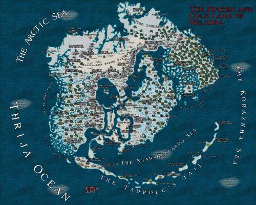
Maps
-
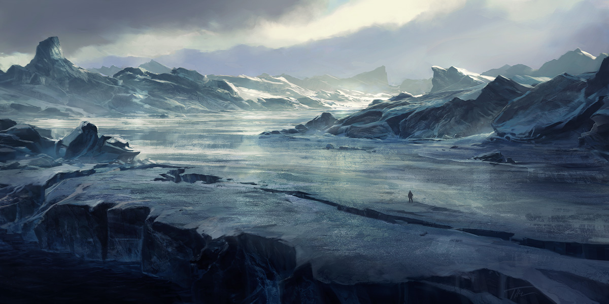
Nelqora
The frozen wasteland of Nelqora. The once seat of the world's greatest empire.
Comments