Geographic Terminology
"In general - that is to say, in places where 'flat' geometry holds sway - it should be relatively simple for species with sufficiently developed linguistic faculties to discuss the relative locations of objects and places in their environment. In one's personal sphere, one might talk about something being above, below, to the left, to the right, before, behind, inside, without, or in other locations relative to one another. On a geophysical scale, it might be possible to talk about things lying to the north, south, east, or west; down is relative to the force of gravity, but, on a globe, this is always percieved to be towards the center of the planet. Even before the advent of devices like compasses - something similar to our magnetic armillaries, but for navigation on the land of The Curved Place - some, like Eyes of the Void believe that navigation by 'astronomical signs' - that is to say, by tracking points of light in the night sky, or 'stars,' as the planet spun past them - would allow one to orient oneself towards true north without recourse to technology.
"Such niceties of communication were left behind with the closing of The Curved Time, however, and we residents of the Manifold Sky must contend with the fact that our mortal prison is not some simple spheroid with easily readable meteorological signs blazing in big bold letters that home is 'that-a-way!' The Voxelians like to call that 'irony' and blame their gods for the practical joke that is our geography. Blame is a fun sometimes, but it isn't very practical in my not-so-humble opinion. No, I prefer the explaination my friends in the grand old Guild give: the world it is what it is, and the world-wise make do with the material, not the ideal. Which brings me to the topic of this aside...
"For most of us not associated with the Guild and for whom one's place of most constant residence is confined to a single point on a cube layer, it is most often advantageous to refer to 'north' as the direction leading across the landscape towards the commissure leading to the nearest cube face associated with the Northern Tesseract, 'south' as the direction towards the Southern Tesseract, and so forth. The north-south alignment is best ascertained through the use of a magnetic armillary or - if you're wealthy, well-connected, or (like me) charming enough towards lady Navigators - a Manifold Reckoner.
"Things get more complicated, however, when you're standing on a cube face with a commissure leading to a north- or south-associated cube within your own tesseract. In these cases, the line towards the other pole along the surface of the cube passes through other directions or, in case you're walking across the commissure on a tightrope or something, the pole might even lie directly above you on a line that passes through the commissure. In these cases, it is usually better to refer to directions based on where the nearest four commissures not on your current face lead, such as heading 'Caudal-way' if you're riding your motorcycle from Vivaldi Peak on Medial C3 towards Craterhold on Medial C2.
"Ah, it makes me miss those wintery Craterhold days just thinking about it, all cozy with a bottle of Caldera Red and a fine Holdswoman on the couch afore the crackling fireplace... but I digress!
"The observant reader will notice that this discussion only addresses the way most of us ground-loving, leaves-of-the-soil folk think about how the space within the Manifold works. This is intentional; for most of us, that's plenty good to make sure we get to our appointments on other faces on time, and road signs and our professional Navigators take care of the more complicated bits. However, for the professional travelling class, including the armed forces of the various nations scattered across our multilateral world, couriers, trade organizations, adventurers like myself, and men of science, a more rigorous accounting of geospatial locations is often essential for mission success.
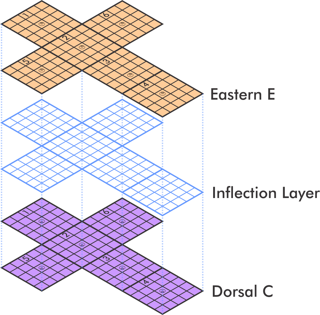
The apparent 'folding' and 'unfolding' of parallel cube layers as one traverses from one side of an inflection layer to another. Notice how, at the very center, the two layers appear completely unfolded and equidistant from one another at all points along their respective surfaces.
"The Navigator's Guild is, obviously, the trend-setter when it comes to the standards of measurement and notation of geographical space. Curiously, for being so specific with their notation, these professional lads and lasses chose to lay out their own maps as though they looked at the world through the distorting lens of life in the inflection layer. Here, the world seems to be unfolded, stretching out in all directions, only seeming to obey the normal rules of perspective when viewed directly above. Indeed, it is my understanding that, from the centermost portion of the inflection layer, the cube layers on either side are always equidistant. Thinking about it has always made my eyes hurt, as though I were seeing anew all over again and risking Edgesight - but nauseating visuals in my mind's eye aside, it proves a marvelous way of disambiguating an otherwise complicated question of cartography.
"From the few Navigator's Guild charts I've been permitted to peruse - at least insofar as I'm willing to admit to - it is apparent that Navigators use a fully alphanumeric annotation system for picking out precise points on a cube face. While many in the public are aware that cubes and their faces are given a letter and number respectively in official documentation, few grasp that this system is designed such that the orientation of things is consistent across all locales relative to the cubes themselves, the tesseracts in which they lie, and, indeed, the five-dimensional Manifold as a whole. The goal of this system is to avoid as much as possible issues of what they call 'holonomy;' even if you cross one of the boundaries into another cube layer, the 'positive' direction on the chart should never change. The 'top right corner' of each face, as viewed on the charts, serves as the origin of 'x' and 'y' coordinate lines subdivided into 50 units of distance each as they progress towards the right and bottom edges of the face respectively; crossing onto another face causes the coordinates to start over, only with the new face's number notation as a prefix.
"In the Navigators' view, spaces in the Manifold are best understood to lie in orientations and locations based upon their connections with one another, through commissures and inflection layers, rather than where they are percieved to lie in three-dimensional space. This is because, while we three-dimensional beings only percieve the single cube in which we are currently standing, all cubes are actually lying atop one another and separated only by the hidden dimensions that we can't percieve. The Navigator's Guild's standards of geographic gradation and measurement are meant to take the place of more linguistically natural terms for directions that - while well-intentioned - tend to confuse the matter more than helping to curry understanding of one's world."
"Unfortunately - and, I imagine, intentionally - the Navigator's Guild standards on this point are conterintuitive to most. For example, you will note that the unfolded 'nets' of a cube are marked such that the 'y' coordinates increase in number as they move towards the long end of the 'cross' formed by the unfolded landscape. This works fine until you manage to get to the top of one of the 'arms,' however, where you suddenly find yourself progressing along the 'x' coordinate instead, perhaps even in a way where the marked numbers are suddenly decreasing. This scheme thus requires constant adjustments on the part of the Navigator. While methodologically rigorous, I have observed in my many travels that it confounds many who work with the Guild and are servile to their nomenclature to try and use the measurements for useful tasks like ballistic calculations. Meanwhile, those of us uneducated rubes that actually have to live on the ground can simply point at the next face over and say 'that's north, simple as!'
"I suppose this is the part of the story where you expect I, your brilliant and handsome paragon of absolute virtue, to hastily pin some sort of moral or lesson to this heap of an explaination. You should use whatever tools are most fruitful in the specific moment you find yourself in and not let your headspace be dominated by the dogma of self-appointed gurus. As for geographic terminology, I haven't the foggiest idea, either. Make it up as you go, I guess?"
Dr. Cynaro Thorne, in musings on his many travels on the way to Courtier of Ironies status.


Comments